top of page

Landscapes

Chilkoot River Valley, Haines Alaska
A few years ago, my wife and I dedided to take a cruise to Alaska on one of the days the ship was going to be docking in Haines. So the day before we were to arrive I decided to call a photographer in Haines and I asked him what he had going the next day. After talking a bit he said he was taking a small group out to the Chilkoot River Valley to photograph grizzly bears coming down the river valley to photograph the bears looking for food. So I told him to sign me up. We met the next day and after a little talk with the group we took off to the valley. We spent about an hour or so photographing bears and then we were getting ready to pack up. While packing up, I happend to turn around and was astounded by the scene of the valley. It was a very dramatic scene with the sun setting, stormly clouds forming and very dramatic. I immediately jumped and fetched my camera from my bag, set up the tripod and was able to
capture this beautiful dramatic scene.

Mt. Hayden North Rim - Grand Canyon

North Shore Mono Lake - Eastern Sierra

Angels Wilndow - North Rim Grand Canyon
Angels Window is one of the North Rim's most photographed formations.
Eons of wind and water sculpted a graceful arch in the Kaibab Limestone,
leaving a narrow fin that now supports the Cape Royal Trail. A protective railing allows visitors to walk safely across the top and peer throug the opening to the river far below. Because Cape Royal Road is only open seasonally, the viewpoint sees fewer crowds that South Rim overlooks, offering quieter contemplation of the canyon's vastness. Interpretive panels explain local geology, while nearby picnic tables invite lingering. The combination of an easy, accessible trail and dramatic scenery makes Angels Window a "must-see" stop on any North Rim itinerarly.
grandcanyon.com/poi/angels-window

Early Morning Solitude - Eagle Lake Acadia National Park
What a beautiful way to start a fall morning than a walk at this gorgeous lake. The morning had a little chill in the air, some fog over parts of the lake and the warmth of the sun seemed to provide a beautiful glow over all the lake. Eagle lake at Acadia National Park is 436 acres and the largest glacier fed fresh water lake in the park. It has a maximum depth of 110 feet
deep and an average depth of 50 feet and is very cold.


In the HOH Rainforest, Olympic National Park
As I was walking thru the HOH rainforest in Olympic National Park, I was in awe of the huge giant trees and the lush greenery of the forest. The forest receives over 189 inches of rain on average each year. The most common trees are the Sitka Spruce, Western Hemlock and the Western Red Cedar some of which can reach over 300 ft high. It was a beautiful spring morning in the forest and the light was just bringing out the richness of the trees. I felt like I was there all alone with tlhose gorgeous giants.

Whispy Clouds over Ruby Beach - Washington

Salt River Canyon - Arizona

Sunrise @ Mt. Olympus-Olympic National Park
I was able to create this image on a beautiful chilly 34 degree morning at Hurricane Ridge in Olympic National Park while I was
with a photography workshop. The sun was just begining to come
up over the ridge and the fog laying over the mountain and it was just a beautiful morning to watch this awesome scene appearing before me and all my fellow photographers. The scene that was
captured was so warm and inviting that we forgot all about the
cold morning and just enjoyed the solitude of the morning.


Earlly Morning Reflections at Jordan Pond
As I was waiting on one of the Park Rangers to join me for a photography class, I dedcided to walk over to Jordan Pond while waiting. It was about 7 am and the water in the pond was just so still that it was llike glass providing wonderful reflections and the low sun shining on the falll colors. I felt moved by it all. Jordan Pond at Acadia National Park is a glacier formed tarn with a maximum depth of 150 feet. There are deep inclines on both the East and the West sides. The water is exceptionally clear with an average visibility depth of 46 feet, the most ever recorded in the state of Maine. It was certainly a beautiful start to my day..
It was early fall and I had decided to drive up to the Eastern Sierra in the hopes of doing some photography. Upon arriving, I was disappointed to find lots of smoke from the recent fires, but, they indicated that I would just have to make the best of it.
The smoke finally did begin to clear, and I was able to capture some beautiful images. I had also wanted to do some night sky photography while there. During the daytime I decided to spend some time scouting out a really nice scene of the Milky Way. So, I drove over to South Mono Lake and spent several hours
looking for just the right scene to capture.
I located what I believed was a great scene with the Milky Way and I went back that night to capture the scene. This photograph I named "Pathway to the Galaxy" because it reminds me of being on some ancient planet. The tall Tufa towers of Mono Lake and the pathway that takes one to the Milky Way Galaxy gives one the feeling of being on some distant planet in another galaxy.
Pathway to the Galaxy
Milky Way over Mono Lake - Eastern Sierra

Moon Rising over Clouds Rest
During a Yosemite workshop in Feburary 2020, our
fearless leader walked us out onto a nearby ledge a little away over from what is known as the Tunnel View overlooking Yosemite Valley. As the sun set behind, the full moon was over snow capped peaks (Clouds Rest) in spectacular fashion.
It was just so awesome! With the sharp contrasts of dark rocks, defiant trees, and clinging snow fields the burnt orange glow gave the impression that we were on lthe moon watching our planet earth rising.
We spent a few hours watching the moon continue to cross over the Yosemite Valley and were just in awe of this beautiful scene unfolding in front of us and were reminded of how small we felt at that moment. A moment that we all will never forget.
Moon Rising over Clouds Rest - Yosemite

Torrey Pines State Reserve - Del Mar, CA

Early Light over Mt. Hayden - Grand Canyon

Oak Creek Canyon - Sedona Arizona
Oak Creek Canyon is widely celebrated as an essential scenic destination for hikers, photographers, and travelers navigating the route between Sedona and Flagstaff. The experience is defined primarily by the breathtaking drive along highway 89A, which offers constant views of dramatic red rock cliffs, lush greenery, and the winding creek. Visitors repeatedly praise the route's stunning natural beauty across all seasons, whether you are driving through or planning to stop, the sheer visual appeal of the canyon makes it a must-see for nature lovers. As I hiked along the creek for an hour or so, it was early fall and the colors were beginning to show themselves along with the early morning light and
and so decided this was a scene worth capturing.

"The Entrance" - HOH Rainforest, Olympic NP
The Hoh Rain Forest, pronounced "Hoe", earns its name from the ever-flowing Hoh River that carves its way from Mount Olympus towards the Pacific Coast. However, where the name originates, is up for debate. The word "HOH" undoubtedly comes from Native American languages: possibly the Quileute word "Ohalet" which means "fast moving water" or "snow water." Since the river itself forms from glacial runoff, that origin seems straightforward. Other explanations state that the Quinault word "Qu," meaning "boundary," could be the root of the name as a river as massive as the Hoh certainly forms a formidable boundary across the landscape. A third consideration claims that the work 'Hoh" translates to "man with quarreling wives." What the actual history behind the name is appears to be lost in time.
Regardless ofl the name, there's no question as to the alllure that draws visitors back to the rainforest year after year. Throughout the winter season, rain falls frequently in the Hoh Rain Forest, contributing to the yearlly average of 140 inches (3.55 meters) of precipation each year. The result is a lush, green canopy of both coniferous and deciduous species. Mosses and ferns that blanket the surfaces add another dimension to the enhancement of the rainforest.
Imagine a climate that rains most of the year. Its average summer temperature doesn't reach above the mid 70s F or low 20s C. The undergrowth is dense and the canopy is thick, providing shade until an old growth giant falls. This is the life in a temperate rainforext. If you were an animal here, where would you live? If you were a plant, how might you survive? The flora and fauna of the Hoh are unique and abundant. So what might you see?
The Hoh Rain Forest is located in the stretch of the Pacific Northwest rainforest which once spanned the Pacific coast from southeastern Alaska to the central coast of California. The Hoh is one of the finest remaining examples of temperate rainforest in the United States and is one of the park's most popular destinations.
When I came upon this scene in the rainforest I new it was one of the oldest and it just made a beautiful entrance into the forest. Just at that time, my group and leader was beginning to move on, and so I had to get my camera gear set up and my camera settings set correctly, along with my composition and I do not like to be rushed. Bult it all worked out and I was able to capture this beautiful North American Giant, so I named it "The Entrance" into this beautiful forest.
Hoh Rain Forest Brochure

Praying Hands of Mary - Glen Lyons Valley -Highlands, Scotland

Sunrise Pahayokee - Everglades National Park

Evening Reflections at Cathedral Crossing - Sedona, AZ
Praying Hands of Mary, Glen Lyon Valley
As no apparent archaeological research has been performed on this formation, one would suspect that it is man-made. The Praying Hands
"pray" towards the conical Creag nan Eildeag. Like all conical hills, they are the symbol of the "primordial hill", the first hill created on Earth -- the naval of the Earth, its shape mimicking the shape of the belly of a pregnant woman. In egypt, the conical hill was identified as a "primordial hill", on which the solar deity masturbated, to create the world In Celtic countries, a very similar event occurs, though it is more correct to say that the solar deity Lugh has impregnated the Caileach, hence the conical shapped hill expressing her pregnancy.
It is on the slopes that rise the so called "praying hands" an enigmatic"
rock formation that has captured the imagination of many. Two huge
stones rise sideways, with a narrow split between them as if they were
two hands, held together without the fingertips touching, as if in prayer.
Taken from Praying Hand of Mary - World Pilgrimage Guide and Martin Gray,

Navaho Point - East Rim Grand Canyon

Flamboyant Fall Colors - Acadia N.P.

Mobious Rock Eastern Sierra

Dead Trees in Lake Havasu

Home of the Ancient Anasazi - Chaco Canyo- New Mexico
Home of the Ancient Anasazi - Chaco Canyo-New Mexico
The Mystery of Chaco Canyon examines the deep enigmas presented
by the massive prehistoric remains found in Chaco Canyon in northwestern New Mexico. It is the summation of 20 years of research.
The film, narrated by Robert Redford, reveals that between 850 and 1150 AD, the Chacoan people designed and constructed massive ceremonial buildings in a complex celestial pattern throughout a vast desert region. Aerial and time lapse footage, computer modeling, and interviews witlh scholars show how the Chacoan culture designed, oriented and located its major buildings in relatlionship to the sun and moon. Pueblo Indians, descendants of the Chacoan people, regard Chaco as a place where their ancestors lived in a sacred past. Pueblo leaders speak of the significance of Chaco to the Pueblo world todaiy.
The Chacoans of the Ancestral Puebloan cultulre (c.850-1150 CE) developed a sophisticated celestial calendar by intergrating their knowledge of the sun, moon, and stars into the design of their architecture, roads, and ceremonial sites.
While the sun and moon were central, the Chacoans also tracked stars and constellations, Rock art, kiva layouts, and architectural features suggest they recorded celestial events such as eclipses, planetary movements, and seasonal star patterns. The dark, clear skies of Chaco Culture National Historical Park preserved visibility of constellations, and modern night sky events there still reflect the cultural importance of stargazing.
www.bullfrogfiles.com.
www.bing.com
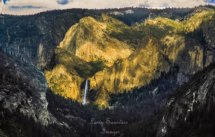
A Dramatic Sunset of Yosemite falls
While on a trip in Yosemite, one evening I decided to take the road up to Tunnel View an on the drive the sun was beginning to drop low in the sky, as it was close to sunset. As I continued up the road,Yosemite valley was becoming more dramatic. So I started looking for a great view as I continued on up. A few minutes later I looked over toward the valley and I said to myself look at that awesome view of Yosemite Valley with that golden suneet coming down over Yosemite Falls. It was just Spectacular. Awesome! What a scene!

Early Morning Sunset @ Mono Lake - Eastern Sierra
As, I was walking along the shore of Mono Lake as the sun was just beginning to rise, I became aware of the peaks of the glowing tufa, the blue of the sky with it's whispy white clouds all reflecting in the lake. It was a gorgeous scene that nature was giving me and I just had to capture it. Then in a few passing moments it had left. A beautifu moment to fill my morning experience at Mono Lake.

Berks of Aberfeldy - Scotland
The Berks of Aberfeldy (birks' from the Scots for birch trees or trees) is a circular walk along the Moness Glen. The gorge with its hanging valleys where streams drown down its slopes. Designated as a Site of Special Scientific Interest for its botantical plant life, believed to be untouched by man for over 8,000 years. The Berks is one of the sites included in the Perthshire Big Tree Country Hertitage and Access project, which celebrates the Perthshire's spectacular natural heritage.

Windstone Arch - Valley of Fire - Neveda
For years the Windstone Arch and Fire Cave inside the Valley of Fire State Park have been popular spots for photographers and tourists alike. That all changed in May 2021 when the delicate arch fell. It hasn't been determined if it was a natural break or if it was caused by vandalism, but the remnants of it are still lying around.
Even if you still decide to visit to view the Fire Cave, the trip is still worth it in my opinion. The hike to the cave is extremely short yet impressive, and the cave is otherwordly. There shouldn't be a ton of people there either, considering the fact that the arch is no longer there.
By: Chris Caplet, June 14, 2023
The best time to photograph Windstone Arch is in the earlly morning, but unfortunatelly for me, when I have gone there to photograph the Arch there is a crowd waiting. When returning in the afternoon, there is nobody around waiting for their turn to crawl into the small cave to take their best shot.
The inage of this cave and arch are featured on the cover of the 2003 book publilslhed by a well known landscape photographer David Muench.
c: Windstone.
Windstone Arch - Valley of Fire - Neveda

Old Shack on Route 395 - Eastern Sierra
The ""old shack"" you see along U.S. Route 395 in the Eastern Sierra is part of a long and layered history tied to the region's ranching, mining, and transportation past. The structure is part of the Frank Sam Cabin, one of the last remaining buildings from Bridgeport Tom's Farmington Ranch. Frank Sam was a descendant of Capitan Sam, a prominent Yosemite-Mono Paiute leader during the Mariposa Indian War. The cabin was built in the late 1920s amd occupied until the early 1960s. serving as a residence for ranch hands and possibly as a family home for the Frank Sam family.
Farmington Ranch was a large landholding in the Eastern Sierra, part of the broader pattern of 19th and early 20th century ranching in California. The area was also shaped by the California gold rush and later by the development of highways like US 395, which connected the Inland Empire to the Eastern Sierra. The ranch's presence reflects the region's mix of Native American heritage., settler ranching, and later tourism.
Today, the cabin is in a state of abandonment, with the remains of a second structure visible nearby. Some interior framing appears to have been recently touched up, suggesting ocasional interest in restoration. The site stands as a quiet reminder of the region's ranching heritage and the changing face of Route 395.
This photograph was taken on one of my photography adventures to the Sierra Mountains, one of my favorrite places to photograph and to hike and explore.. From where I left from my home, 395 is the best route to take and the most adventureous and I knew there had been some snow up there went I left. As I begain to get closer to the Sierra Mountains, I began to see the old shack which I had seen many times while drivintg up on other adventures. As I got closer to the Old Shack, which I had seen many times before, I was astounded by all the snow and clouds behind the old shack and had to stop and set up my camera for this gorgeous scene.
https://www.bing.com/search?q=history+of+old+shack+on+route+395&qs=CGS&pq=history&sc=12-7&cvd=8EB5FC2D9FA641248G38VGR21FBBRG

The Wave, Vermilion Cliffs National Monument
The Vermilion Cliffs National Monument is located in northern Coconino County, Arizona, U.S, immediately south of the Utah state line. This national monument, 293,689 acres in area, protects the Paria Plateau, Vermilion Cliffs, Coyote Buttes, and Paria Canyon. Elevations in the monument range from 3,100 feet to 6,500 feet above sea level (944 to 1,981 meters).
Human settlement in the region dates back 12,000 years; hundreds of Native American pueblos are spread across the monument. The remains of the natives' villages, with houses, granaries, burial areas, and associated ruins, can be found here. The monument also contains one of the largest collections of rock art sites in any nationally protected area. Many of these petroglyphs are believed to be among the oldest in the United States.
The first Europeans to visit the region were Spanish missionaries and explorers from the 1776 Dominguez-Escalante expedition. Later, Mormon explorers searched the region during the 1860's some of them settling on land that is now within the monument.
Below the Vermilion clliffs runs the historisc "Honeymoon Trail", a wagon route for Mormons who journeyed to and from the temple at St. George, Utah to have their marriages sealed. The route, through remote country, was otherwise seldom used. Historical markers denote its history. Today, the region surrounding the monument is relatively unspoiled with few roads and virtually no permanent inhabitants.
https://en.wikipedia.org/wiki/Vermillon_Cliffs_National_Monument
© 2022 by Larry A Saunders. Proudly created with Wix.com
bottom of page